
IMD File Extension
GIS Image Metadata Format
-
Category
-
Popularity5 (2 votes)
What is IMD file?
IMD is a file extension commonly associated with GIS Image Metadata Format files. IMD file format is compatible with software that can be installed on Windows system platform. Files with IMD extension are categorized as GIS Files files. The GIS Files subset comprises 255 various file formats. The software recommended for managing IMD files is ArcGIS Desktop. On the official website of Esri developer not only will you find detailed information about theArcGIS Desktop software, but also about IMD and other supported file formats.
Programs which support IMD file extension
Programs that can handle IMD files are as follows. IMD files can be encountered on all system platforms, including mobile, yet there is no guarantee each will properly support such files.
 Windows
How to open file with IMD extension?
Problems with accessing IMD may be due to various reasons. On the bright side, the most encountered issues pertaining to GIS Image Metadata Format files aren’t complex. In most cases they can be addressed swiftly and effectively without assistance from a specialist. We have prepared a listing of which will help you resolve your problems with IMD files.
Step 1. Get the ArcGIS Desktop
 The main and most frequent cause precluding users form opening IMD files is that no program that can handle IMD files is installed on user’s system. To address this issue, go to the ArcGIS Desktop developer website, download the tool, and install it. It is that easy Above you will find a complete listing of programs that support IMD files, classified according to system platforms for which they are available. The safest method of downloading ArcGIS Desktop installed is by going to developer’s website (Esri) and downloading the software using provided links.
Step 2. Check the version of ArcGIS Desktop and update if needed
 You still cannot access IMD files although ArcGIS Desktop is installed on your system? Make sure that the software is up to date. Software developers may implement support for more modern file formats in updated versions of their products. The reason that ArcGIS Desktop cannot handle files with IMD may be that the software is outdated. The latest version of ArcGIS Desktop should support all file formats that where compatible with older versions of the software.
Step 3. Associate GIS Image Metadata Format files with ArcGIS Desktop
After installing ArcGIS Desktop (the most recent version) make sure that it is set as the default application to open IMD files. The process of associating file formats with default application may differ in details depending on platform, but the basic procedure is very similar.
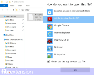
Selecting the first-choice application in Windows
- Choose the entry from the file menu accessed by right-mouse clicking on the IMD file
- Next, select the option and then using open the list of available applications
- Finally select , point to the folder where ArcGIS Desktop is installed, check the Always use this app to open IMD files box and conform your selection by clicking button
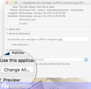
Selecting the first-choice application in Mac OS
- By clicking right mouse button on the selected IMD file open the file menu and choose
- Open the section by clicking its name
- Select ArcGIS Desktop and click
- A message window should appear informing that This change will be applied to all files with IMD extension. By clicking you confirm your selection.
Step 4. Ensure that the IMD file is complete and free of errors
If you followed the instructions form the previous steps yet the issue is still not solved, you should verify the IMD file in question. Being unable to access the file can be related to various issues.

1. The IMD may be infected with malware – make sure to scan it with an antivirus tool.
If the IMD is indeed infected, it is possible that the malware is blocking it from opening. Immediately scan the file using an antivirus tool or scan the whole system to ensure the whole system is safe. If the IMD file is indeed infected follow the instructions below.
2. Ensure the file with IMD extension is complete and error-free
If the IMD file was sent to you by someone else, ask this person to resend the file to you. It is possible that the file has not been properly copied to a data storage and is incomplete and therefore cannot be opened. If the IMD file has been downloaded from the internet only partially, try to redownload it.
3. Ensure that you have appropriate access rights
There is a possibility that the file in question can only be accessed by users with sufficient system privileges. Log out of your current account and log in to an account with sufficient access privileges. Then open the GIS Image Metadata Format file.
4. Make sure that the system has sufficient resources to run ArcGIS Desktop
If the systems has insufficient resources to open IMD files, try closing all currently running applications and try again.
5. Ensure that you have the latest drivers and system updates and patches installed
Latest versions of programs and drivers may help you solve problems with GIS Image Metadata Format files and ensure security of your device and operating system. It may be the case that the IMD files work properly with updated software that addresses some system bugs.
Do you want to help?
If you have additional information about the IMD file, we will be grateful if you share it with our users. To do this, use the form here and send us your information on IMD file.
File Extension of the day

PDO file is digital origami file created with Pepakura Designer software tool. Origami is commonly associated with Japanese culture, and Japan is w...