
ZLAS File Extension
ESRI Optimized LiDAR Data Format
-
Category
-
Popularity0 ( votes)
What is ZLAS file?
ZLAS is a file extension commonly associated with ESRI Optimized LiDAR Data Format files. ZLAS file format is compatible with software that can be installed on Windows system platform. Files with ZLAS extension are categorized as GIS Files files. The GIS Files subset comprises 255 various file formats. ArcGIS is by far the most used program for working with ZLAS files. On the official website of Esri developer not only will you find detailed information about theArcGIS software, but also about ZLAS and other supported file formats.
Programs which support ZLAS file extension
Below is a table that list programs that support ZLAS files. ZLAS files can be encountered on all system platforms, including mobile, yet there is no guarantee each will properly support such files.
 Windows
Updated: 09/05/2020
How to open file with ZLAS extension?
There can be multiple causes why you have problems with opening ZLAS files on given system. On the bright side, the most encountered issues pertaining to ESRI Optimized LiDAR Data Format files aren’t complex. In most cases they can be addressed swiftly and effectively without assistance from a specialist. The following is a list of guidelines that will help you identify and solve file-related problems.
Step 1. Download and install ArcGIS
 Problems with opening and working with ZLAS files are most probably having to do with no proper software compatible with ZLAS files being present on your machine. The solution to this problem is very simple. Download ArcGIS and install it on your device. The full list of programs grouped by operating systems can be found above. If you want to download ArcGIS installer in the most secured manner, we suggest you visit Esri website and download from their official repositories.
Step 2. Update ArcGIS to the latest version
 You still cannot access ZLAS files although ArcGIS is installed on your system? Make sure that the software is up to date. Sometimes software developers introduce new formats in place of that already supports along with newer versions of their applications. If you have an older version of ArcGIS installed, it may not support ZLAS format. The most recent version of ArcGIS is backward compatible and can handle file formats supported by older versions of the software.
Step 3. Assign ArcGIS to ZLAS files
If you have the latest version of ArcGIS installed and the problem persists, select it as the default program to be used to manage ZLAS on your device. The next step should pose no problems. The procedure is straightforward and largely system-independent
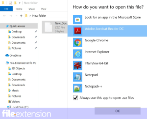
Selecting the first-choice application in Windows
- Clicking the ZLAS with right mouse button will bring a menu from which you should select the option
- Click and then select option
- Finally select , point to the folder where ArcGIS is installed, check the Always use this app to open ZLAS files box and conform your selection by clicking button
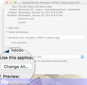
Selecting the first-choice application in Mac OS
- Right-click the ZLAS file and select
- Open the section by clicking its name
- Select the appropriate software and save your settings by clicking
- Finally, a This change will be applied to all files with ZLAS extension message should pop-up. Click button in order to confirm your choice.
Step 4. Check the ZLAS for errors
You closely followed the steps listed in points 1-3, but the problem is still present? You should check whether the file is a proper ZLAS file. Problems with opening the file may arise due to various reasons.
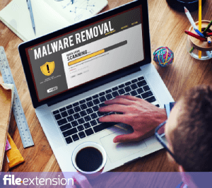
1. Check the ZLAS file for viruses or malware
Should it happed that the ZLAS is infected with a virus, this may be that cause that prevents you from accessing it. It is advised to scan the system for viruses and malware as soon as possible or use an online antivirus scanner. If the scanner detected that the ZLAS file is unsafe, proceed as instructed by the antivirus program to neutralize the threat.
2. Ensure the file with ZLAS extension is complete and error-free
Did you receive the ZLAS file in question from a different person? Ask him/her to send it one more time. The file might have been copied erroneously and the data lost integrity, which precludes from accessing the file. If the ZLAS file has been downloaded from the internet only partially, try to redownload it.
3. Check if the user that you are logged as has administrative privileges.
There is a possibility that the file in question can only be accessed by users with sufficient system privileges. Log out of your current account and log in to an account with sufficient access privileges. Then open the ESRI Optimized LiDAR Data Format file.
4. Check whether your system can handle ArcGIS
If the system is under havy load, it may not be able to handle the program that you use to open files with ZLAS extension. In this case close the other applications.
5. Ensure that you have the latest drivers and system updates and patches installed
Latest versions of programs and drivers may help you solve problems with ESRI Optimized LiDAR Data Format files and ensure security of your device and operating system. It may be the case that the ZLAS files work properly with updated software that addresses some system bugs.
Do you want to help?
If you have additional information about the ZLAS file, we will be grateful if you share it with our users. To do this, use the form here and send us your information on ZLAS file.
File Extension of the day

SSF files are associated with Trimble Navigation, a GPS mapping software. SSF files store data generated by Trimble Navigation - it is a kind of a ...